
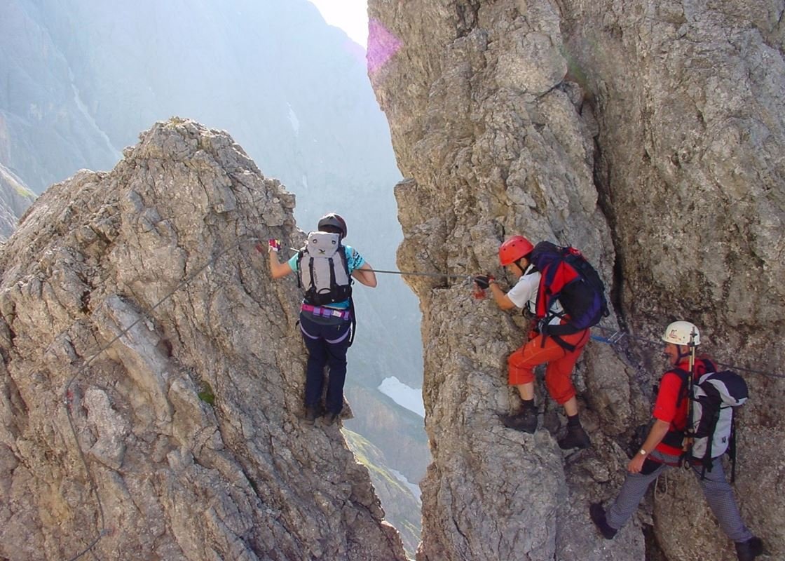
Via Ferrata Königsjodler
Conquiste seu espaço
Seja o que for, o modo de contar sua história on-line faz toda a diferença.
The Königsjodler Klettersteig is a high-alpine via ferrata situated on the massif of Hochkönig (Austria) and ranks among the most demanding iron-paths in the Eastern Alps. With its long altitude gain, exposed ridge sections and considerable duration, the route offers a true mountaineering experience for seasoned climbers. It combines thrilling climbing, dramatic scenery and alpine endurance in one continuous excursion.
Trail Overview
Location: Hochkönig massif in the Salzburger Land region of Austria.
Route type: Via ferrata (Klettersteig) with permanent steel cable, ladders and fixed anchors.
Difficulty rating: Typically graded C/D with demanding sections and sustained exposure.
Altitude span & elevation gain: The climb reaches a summit point near 2,900 m; total elevation gain around 1,700-1,900 m depending on access.
Approximate length / duration: The complete tour often takes 10–12 + hours; some sources quote ~25 km and 12 hours duration.
Terrain: Rocky alpine ridge, exposed flanks, steep ascents, fixed steel works, culminating in high-mountain terrain.
Route Description
The Königsjodler Klettersteig begins with the approach to the Hochkönig massif, typically from a valley base at approximately 1,300–1,400 m. After reaching the via ferrata’s entry point, the route progresses steadily upward through steep terrain, often following a narrow ridge. Key segments include the ascent of the Teufelshörner, crossing the Kematstein and finally culminating at the summit of the Hohen Kopf (“High Head”) at about 2,875–2,904 m.
Once atop, the descent is described as particularly tricky: the route down via the Birgkar (glacier cirque) is steep, loose and requires high concentration. Because of its length and complexity, the full traverse is only recommended in very stable weather.
From the summit or completion point one either retraces steps or descends via an alpine path to a hut or valley station. The entire journey demands solid planning, early start and good physical reserve.
Highlights
Alpine ridge exposure and panoramic views: The route sweeps across lofty ridges with full views of surrounding peaks and glaciers, creating a memorable high-mountain experience.
Length and endurance challenge: Few via ferratas match its sustained vertical gain and duration, making it a statement climb in itself.
Summit achievement at nearly 2,900 m: Arriving at the Hohen Kopf summit after the Klettersteig portion is a true sense of accomplishment.
Varied climbing features: From fixed cable sections and metal rungs to steep rock faces, this route mixes typical via ferrata aids with authentic alpine terrain.
Remote, less crowded alpine terrain: Despite its reputation, the length and difficulty keep numbers modest, offering a more solitary mountain experience.
Difficulty & Required Skills
This route is classified as very difficult (grade C/D) in the Klettersteig system.
Technical requirements:
Proficiency in via ferrata techniques: securing harness, using lanyard, managing exposed terrain.
Strong upper body strength: constant use of arms in steep sections.
Excellent sure-footedness and head for heights: many exposed traverses.
Alpine experience: dealing with long durations, weather shifts, descent through high-alpine terrain.
Physical demands: Long ascent, high elevation, many hours of sustained effort—only for experienced climbers.
Risk factors: Exposure, potential rockfall, the descent is rated tricky and requires caution. Avoid in bad weather or wet rock.
Equipment needed: Via ferrata kit (helmet, harness, energy-absorbing lanyards), sturdy mountaineering boots, gloves, layers for alpine weather, possibly crampons/ice gear if snow remains.
When to Go
Best period: Mid-summer (July to early September) when snow is melted, routes are dry, days are long and huts operate.
Avoid: Early season when snow/ice remain, as the descent becomes hazardous. Late season when weather turns and daylight falls shorter.
Time of day: Start early (before sunrise) to allow sufficient hours, and to avoid afternoon thunderstorms common in high mountains.
Weather dependence: Because of exposure and high altitude, only attempt in stable weather; thunderstorms or wet rock significantly increase danger.
Access & Logistics
Approach: Access the Hochkönig massif via the valley road to the base village (such as Mühlbach or interface towns). From the valley, ascend via cable car or hiking to hut or ridge base.
Starting point coordinates: The entry point is in the Hochkönig region; e.g., one reference gives 47.392163 N, 13.048183 E.
Accommodation: Mountain huts are available in the region; due to the length of the route an overnight stay before or after is highly recommended.
Descent options: After summit, return either via the same route or via alternate alpine trail/ski basin descent to valley. Ensure you have transport or hiking plan.
Equipment transport: Some routes may involve cable-car up to access zone; check local transport schedules.
Preparation advice: Carry map (1 : 25 000 or relevant), GPS device, first aid kit, sufficient water and food for long day.
Why It Belongs on Every Adventurer’s List
The Königsjodler Klettersteig is not just a via ferrata—it is a full mountain odyssey. Few routes offer such a powerful mix of endurance, technical climbing, exposure and high-alpine beauty in one package. For the climber who seeks more than a short “via ferrata fun” and wants a genuine mountain summit via fixed steel, this route delivers in spades. You will traverse ridges where the world falls away below, stand on a high summit at nearly 2,900 m, and immerse yourself in the rugged grandeur of the Alps. It’s a test of body and mind, but the reward is an unforgettable mountain moment.
If you’re ready for a serious alpine adventure—equipped, prepared and weather-aware—this route belongs on the list of must-do high mountain climbs.