
Via Ferrata d’Engins
Nestled in the foothills of the Vercors Massif above the village of Engins (Isère, Auvergne-Rhône-Alpes, France), the Via Ferrata d’Engins offers a compact but spectacular vertical adventure. This protected climbing route ascends the cliffs above Engins, delivering fine views over the Grenoble basin and introducing climbers to the thrilling world of via ferrata: steel cables, rungs, ladders and exposed rock faces turned into a fully-equipped pathway. For hikers and mountaineers alike, it provides an accessible yet exciting taste of vertical terrain, combining alpine ambiance with ease of access from the Grenoble area.
Trail Overview
Location: Engins, Isère, Auvergne-Rhône-Alpes, France
Vertical exposure: The route climbs the steep limestone cliffs of the Vercors massif above Engins.
Route length & time: Typically half-day (2-4 h) including access and return.
Equipment required: Via-ferrata set (harness, shock-absorbing lanyards, helmet), gloves, proper mountain footwear.
Grade / Difficulty: While exact official grade sources are scarce for this specific route, the surrounding region uses French via-ferrata ratings (F, PD, AD, D, TD). Given the verticality and exposed nature of Engins, one should assume a moderately difficult grade – around AD to D.
Best season: Late spring to early autumn (June to October) when the cliff is dry and safe.
Route Description
From the village of Engins you follow the signed trail that climbs from the valley floor into the cliff wall region. The approach walk takes you through forested slopes and pastures up to the base of the cliff where the via‐ferrata begins.
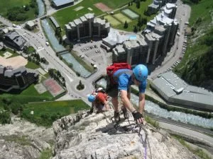
Once on the steel ladder/rung zone you will ascend vertically or semi-vertically along the rock face, clipping into fixed cables. The route offers a sequence of exposed traverses, ladders and possibly steps carved into the rock. As you climb, the valley begins to drop away and the views open towards the Grenoble basin and the high plateaus of Vercors.
Mid-route there may be resting ledges or vantage points where you pause, take in the panorama and gather your strength. The final section brings you to the top of the cliff or ridge, often a small plateau or path that links back to a descent trail. From the summit of the via you descend back to Engins via footpath – the return hike may be through forest or along ridge and gives a chance to relax after the vertical effort.
Note: Because precise route mapping is limited in public sources, always check locally for current condition, signage and official entry.
Highlights
Dramatic exposure and verticality: The route offers a tangible sense of height and rock face progression – an exhilarating contrast to gentle valley walks.
Panoramic views: At the top you are rewarded with sweeping vistas of the Grenoble valley, the Chartreuse and Vercors ranges, and the Engins village tucked below.
Accessible from Grenoble: Unlike remote alpine via-ferratas, Engins is near a major urban centre – ideal for combining adventure with convenience.
Natural setting in Vercors: Limestone cliffs, alpine flora and fauna, with the quiet characteristic of the Vercors massif add character to the experience.
A bridge between hiking and climbing: For hikers looking to step up their game, this route bridges the gap to more technical terrain without full mountaineering commitment.
Difficulty & Required Skills
Physical demands: Good fitness is needed. While the route is not full rock-climbing, you will spend significant time ascending via rungs and cables with arms and legs engaged.
Technical skills: Basic via-ferrata competency (comfortable with heights, ability to clip/unclip safely, secure on ladders/traverses). No advanced climbing techniques required, but you must be sure-footed and confident in exposed terrain.
Height & exposure: Expect vertical or near-vertical rock faces; exposure might feel significant if you’re not used to them.
Weather and rock conditions: Wet or icy rock greatly increases difficulty. Avoid in storms or wet conditions – metal rungs become slippery and cables conduct electricity.
Equipment: A proper via-ferrata kit is mandatory: harness, twin-arm shock-absorbing lanyard, helmet, gloves. Sturdy hiking boots with good grip. Bring enough water and possibly a head-lamp if you finish late.
In summary: this route is moderately difficult – not for absolute beginners, but well within reach of hikers who have done alpine trails and want to try a vertical dimension.
When to Go
Best months: June to October. In early summer the rock is dry and stable; in autumn you’ll enjoy crisp air and fewer crowds.
Avoid: Times of heavy rain, storms, later autumn when rock may be slippery or early snow/ice appears on the cliff.
Crowd factor: Because of its proximity to Grenoble, weekends in high season (July/August) may be busier; early morning or weekdays are quieter.
Time of day: Start early in the morning to benefit from cooler rock and good light, and finish descent before afternoon heat or storms develop.
Access & Logistics
Getting there: Travel to Engins (Isère) via Grenoble. From Grenoble take local road up to Engins, park at the village or trailhead parking. Public transport is possible via bus from Grenoble to Engins (check local schedules).
Trailhead: From Engins centre follow signage to the via-ferrata start (often marked “Via Ferrata d’Engins” or simply “Via Ferrata Engins”). The approach trail is well marked.
Duration: Allow 2-4 hours depending on your pace, stamina and conditions (including approach and return).
Return: After completing the via section, walk down via marked footpath to Engins. Ensure you have enough daylight for descent.
Gear rental/guides: Local outdoor activity companies in the Grenoble/Isère region offer via-ferrata kits and guided sessions – recommended if you are new to the format.
Safety check: Check weather forecast, rock condition and whether the route is open. Since via-ferratas are subject to closures due to rockfall or maintenance, confirm locally.
Why It Belongs on Every Adventurer’s List
The Via Ferrata d’Engins is an ideal adventure for anyone seeking to bridge the gap between hiking and full alpine climbing. It offers vertical thrills, panoramic mountain scenery, and the convenience of being close to an urban base. For your All Hiking audience – who specialise in alpine experiences, nature photography and outdoor lifestyle – this route ticks all the boxes: aesthetic rock faces, high-adrenaline movement, and the backdrop of the majestic Alps.
Whether you’re a photographer keen to capture the ridge-line, a hiker looking to level up your skill set, or simply someone chasing mountain-vibes with less commitment than a multi-day trek, this via-ferrata delivers. It complements your content on alpine trails by adding a “vertical dimension” to the trails database and provides your readers with a memorable, shareable outdoor challenge.