
Via Ferrata de la Tour du Jallouvre
Located in the heart of the Aravis mountain range above Le Grand‑Bornand (Haute-Savoie, France), the Via Ferrata de la Tour du Jallouvre offers a thrilling and scenic climbing experience. With its steel cables, rungs, hanging footbridges and exposed sections, it is a standout in the region for those seeking a strong vertical and alpine challenge.
Location & Setting
Region: Aravis massif, Haute-Savoie, France.
Starting point: Near the hamlet of Le Chinaillon (above Le Grand-Bornand) and near the Col de la Colombière.
Altitude: The via ferrata is situated roughly between ~1,400 m and ~2,000 m above sea level.
The terrain is limestone rock, west-facing, with dramatic exposure and impressive vertical elements.
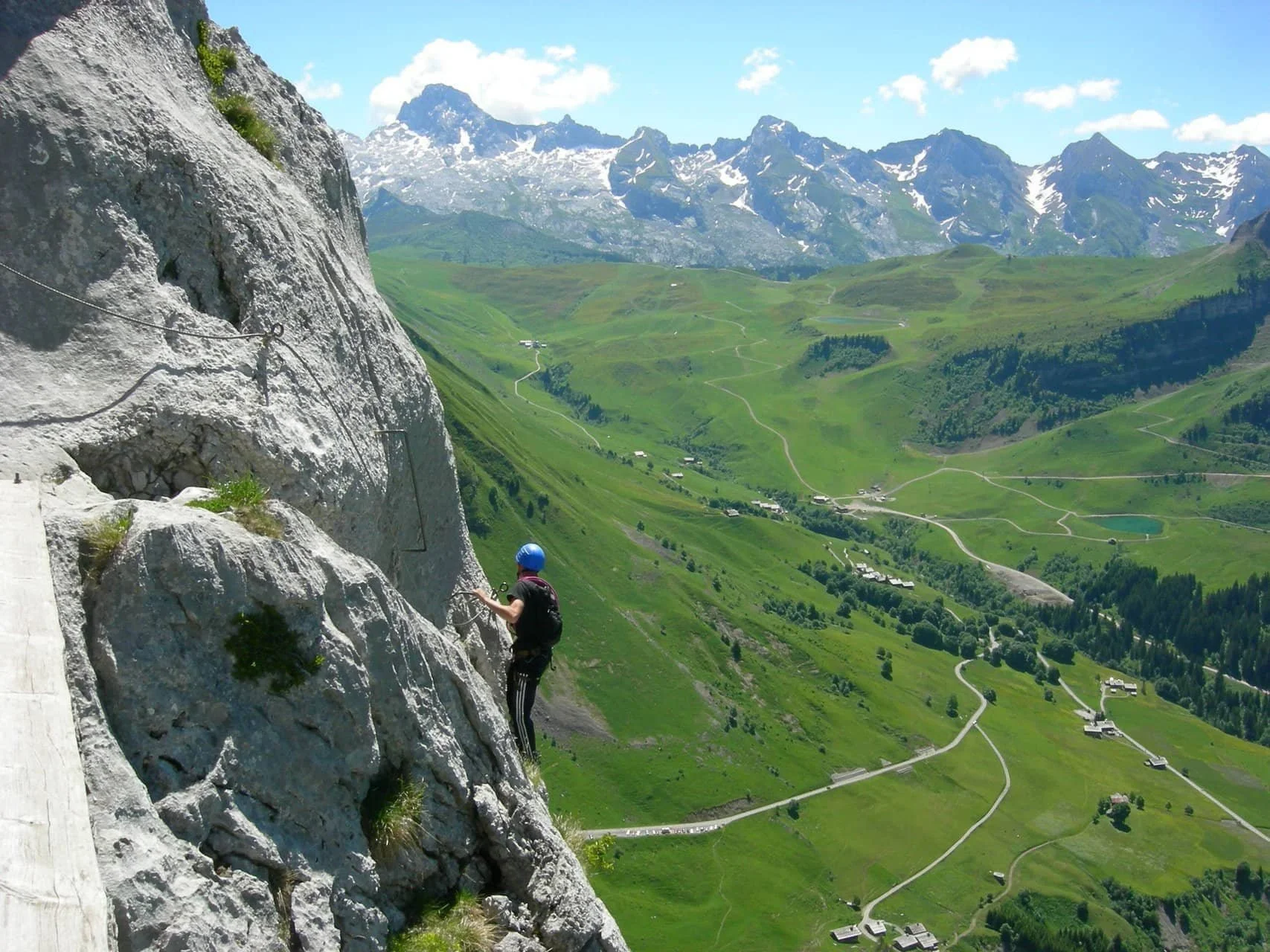
Route Description & Key Sections
The Via Ferrata de la Tour du Jallouvre features a well-defined route with several memorable segments:
Approach (~20–30 minutes): From the parking or trailhead, a short hike reaches the start of the via ferrata.
Initial traverse: The route begins with traversing ledges up and left over good quality rock toward the “Arche du Bouquetin” (Ibex Arch).
Crux – “Cul Tourné”: A slightly overhanging section requiring climbing-style moves. The name “Cul Tourné” (turning your rear end) evokes the awkward, exposed nature of the step.
Suspension Bridge – “Passerelle du Gypaète”: A hanging footbridge that crosses high above the face, offering an aerial thrill.
Pillar & ridge climb: After the bridge, you climb a pillar, traverse a long rock face, and ascend via an arête to the summit of the tower.
Descent: The descent path takes about 1 hour from the summit back toward the parking (depending on route) and may include steep terrain.
Route Variants & Difficulty
There are three main route options on this via ferrata:
Classic route: ~ 1,100 m length, rated D+ (French via‐ferrata grade) in difficulty.
Escape/short version: ~ 500 m long, offers exit option after the first part. Also rated D+.
Eterlou variant: rated AD (Assez Difficile) — a slightly easier variation.
On international grading (e.g., the via-ferrata letter grades), the route is often listed as C/D.
Estimated time: 3 – 4.5 hours for the main route (excluding approach/descent).
Given the length, exposure, and technical moves, this is considered one of the more demanding via ferrata routes in the Aravis region.
Why It’s Special
The combination of overhangs, suspension footbridges, vertical pillar climbs and exposed ridges gives a real alpine flavour.
Magnificent panoramic views across the Aravis massif and, on clear days, toward the Mont Blanc massif.
Wildlife may appear — ibex and bearded vultures (gypaetes) inhabit the area. The footbridge is named “Passerelle du Gypaète” in recognition.
The setting: high-mountain limestone, west-facing rock, giving dramatic light and strong sense of altitude.
Practical Information & Logistics
Access & Parking:
From Le Grand-Bornand/Le Chinaillon drive toward Col de la Colombière. Parking near Chinaillon and trailhead.
Hike ~20-30 minutes from parking to the start of the equipped route.
Season & Conditions:
Open generally from end of May to end of October, depending on snow conditions.
Being west-facing, rock and equipment heat up in sun; afternoon thunderstorms typical in Alps — start early.
Gear Required:
Standard via-ferrata gear: helmet, harness, via-ferrata lanyard (energy absorber), gloves.
Good mountain boots with grip.
Given exposure and some overhangs, some climbing strength and confidence in airy exposures required.
For shorter/escape version, you still carry full kit as the route is exposed.
Guiding / Booking:
For less experienced participants or groups, consider going with a certified mountain guide/local bureau.
Some guides quote full-day rates (~70 € per person) for via ferrata and mountain terrain.
Descent:
After the summit of the tower, descend via the marked footpath. It may involve exposed terrain; remain alert.
Allow ~1 hour for descent.
Safety & Experience Tips
Confirm rock and weather conditions the morning of. Sudden changes or wet rock increase risk.
Use early start (first ascent) for best condition and fewer people.
Bring sufficient water and energy snacks — the physical demand is high.
If you fear heights or have weaker arms, the shorter variant (500 m) may be more suitable.
Respect the mountain environment: due to past predator-prey regulation in the area (ibex), some zones may have restrictions on dogs or shepherd-dog pastures.
The route is lengthy: ensure you have adequate daylight remaining to complete descent safely.
Who Should Attempt It?
This via ferrata is not for beginners. It’s ideal for hikers/climbers who:
Have previous via‐ferrata or alpine experience
Are comfortable with exposed terrain and moderate overhangs
Have good physical fitness and upper body/arm endurance
Want a full-day challenge rather than a casual half-day outing
For families or less experienced participants, the shorter variant or other easier via ferratas in the region may be more appropriate.
Summary
The Via Ferrata de la Tour du Jallouvre is a high-quality alpine via ferrata that blends verticality, exposure, and scenic mountain environment. With its crux sections, hanging bridges and impressive panoramic setting it offers a memorable adventure for those prepared. It stands out not simply as a via-ferrata route, but as a mountain journey combining physical challenge and mountain atmosphere.